|
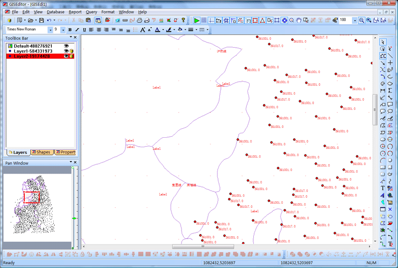
GisEditor function and operation
Introduction
Simply
put,
GIS system will
describe the location (place) combines layers of
information, through which information can make you
a better understanding of the location (place).
You can
choose which layers as needed information, such as
the lot to find a better set up shop, analyzing
environmental damage, through an integrated city in
the same crime, that type of crime and so on.
GisEditor
is UCanCode latest
GIS-specific solutions,
the official version provides all of its
100% source code.
All code used in all
VC + + / MFC
development made for the application you develop
any Gis save a lot of
time.
GisEditor
solve the basic problem is: through the layers to
build a multi-level maps, point layer is divided
into layers, line layer and the surface layer.
Surface rendering at the bottom,
line layer Secondly, points plotted in the top
layer.
Single layer can be any database
table to establish the appropriate properties,
property database table can be defined according to
the needs the appropriate database fields.
Database tables stored in the
corresponding data source.
Layer in any of the current pixel
can be free to choose whether the database tables
added to the property, if the increase in, the
association may want to set the corresponding
property value.
A graph element can be set with any
number of related database records.
System provides a complete operating
functions of the layer, such as: add, delete,
change.
Layer in the element attribute data
are free to edit, query.
Layers of the attribute data can be
queried, the output reports and statistical charts.
At the same time the system also
supports importing external
ArcView Shape
files.
GisEditor
database
GisEditor
database is a spatial database.
In addition to type text or numbers
stored in the attribute data, you can also save
point, line or polygon vector data types.
In
GisEditor database,
support for hierarchical structures.
This means: you can set different
levels of
Gis project, each place
different graphical elements.
Of course, can also be calculated on
the basis of statistics and output reports.
GisEditor
database is also time-series databases, all data are
associated with dates.
So you can see the time change in
the attribute data path.
All the properties for the
GisEditor
design data are stored in a database file, the
system default database is provided
Micrososft Access
database, you can use this database file to package
redistribution.
The structure of the database
features and attributes, you can define the project
needs the corresponding data dictionary.
To meet the needs of the project.
Map
Each layer contains a spatial
attribute, such as: administrative boundaries, or a
village location, as well as text or numeric
attribute as a label, for example, in the village,
or in the number of households above the poverty
line name.
You can create a thematic map,
pursuant to the specific data analysis shows the
decision by the layers.
For example, you can be
administrative divisions as a graphic, you can use
different colors to represent the housing and
climate change.
Use of E-XD++
powerful editing features, you can easily modify any
of the geometric characteristics of graphics, such
as the type and appearance of signs and labels
positioning and so on.
In
GisEditor, you are free to
decide whether a pixel into a meaningful database or
not, if placed in the database, the database will be
located under the layer of the primitive definition
of the database table for the corresponding database
record.
Query
Use
GisEditor, you can enter
the conditions to complete the query and report
shows, for example, you can enter certain conditions
show only income less than 1200
yuan village, and its fill color to red.
These features allow you to better
control what to display.
You are free to set the query, for
example: can only select or display the data in
2010 does not belong to the formal settlers
and only in the construction of housing for
families.
Enquiries can also be used for
statistical calculations.
For example, you can calculate the
number of families below the poverty line.
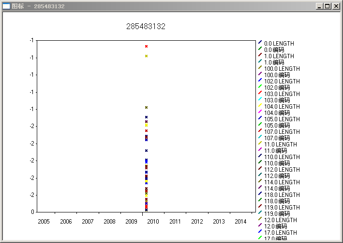
You can also output data histograms,
time series graphs and pie charts.
Image Digital
GisEditor
support including the printing of digital maps.
By providing a comprehensive tool
GisEditor any completed a
map of digital image files.
In the digital, you can import image
files through the way of any image file into the
canvas as a background base map, and then digitizes
it.
Printed maps can be a little
scanner and other devices to the computer directly
to save the image acquisition to the corresponding
image file, then save the image file into the canvas
to complete the digital image file.
Data can be directly encoded.
You can also encode data
Excel spreadsheet, then
import the Excel file.
Projection
Earth and the latitude and longitude
coordinates on a map using Cartesian
(The x, y)
coordinate transformation is called map projection.
Latitude /
longitude coordinates and representatives around the
equator and the Earth's distance from the Greenwich
meridian difference, when we use the map displayed
on the computer screen or map the spherical
coordinates (D) must be converted to plane (D
conversion) coordinates for specific areas of the
earth.
This is the
projection.
GISEDITOR data storage and
the corresponding coordinates (x,
y) of the associated primitives.
When
the data in latitude
/ longitude converted to
x, y coordinates using the
default stored in the database before the projector.
When you import
GISEDITOR data, it will automatically
determine whether the latitude /
longitude data, or x, y
coordinates and convert the data needed.
A
UTM
Projection
When you first
GISEDITOR create a new database, you will be
told not define the default projection.
Choose to define a
new projection.
Operation is as follows:
1),
select "Database | Map
Projection Settings" submenu.
2)
can be defined in the following dialog box, map
projection.
Then the following dialog box will
appear:.
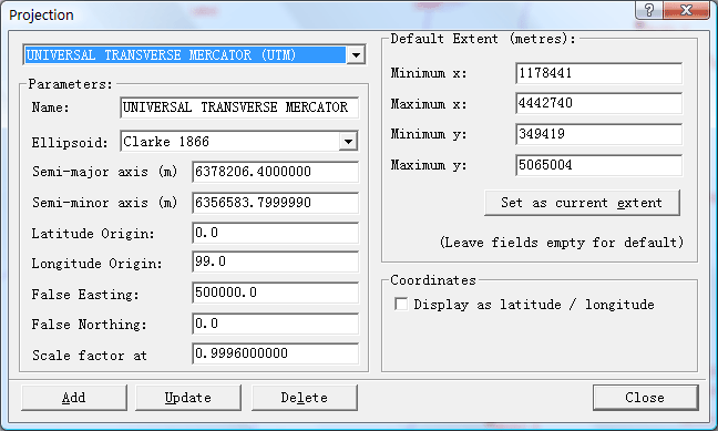
In this dialog box, as you need to
set the appropriate parameters.
Creating thematic
maps
Thematic map is in color or
line styles and symbols unified map.
For example, the size of the village
sign on behalf of its population.
Create thematic maps, the first
layer added to the map included spatial attributes
(line
/ polgons or coordinates)
and the label is mapped theme.
Layers dialog box from the map, you
can add a new layer and select the surface type, you
can also use the cover illustration shows the
shapefile file.
Note: Add a layer, make sure
you have configured the appropriate data source, and
set up the appropriate map projection.
Data Dictionary
Data dictionary defines the data
structure GISEDITOR
features and their properties database.
This is similar to the
relational database tables and columns.
Of course there is some difference
and relational databases, including:
1),
pixel level can be arranged, the property features
of the data field may be his son.
For example, the
'village' may have a
parent feature 'area'.
And text attributes (numbers, text,
notes, etc.) data, but also can have spatial
attributes (coordinates, polyline
/ polygon or geographic coordinates, links,
image files), to be mapped.
For
example, there may be a county boundary line type
/
polygon attribute field.
2),
all features have a default name.
For
example, the 'village' is
probably the name of 'Third
Stream', 'river', etc.
All attribute fields are associated
with a date.
For example, the 'population'
and changes over time.
Any property fields are likely to
change over time, such as: administrative
boundaries, rivers, etc.
The structure of your data dictionary
will reflect the information you want to store and
use the output of the report content
GISEDITOR.
Usually this is the simplest
structure of the database to reflect your
administrative structure of the project area.
For
example, you can create
For the
'province', 'City', 'county' and
'family' and so primitive,
for each pixel, you create the attribute data tables
to store their information.
And automatically has a name
and a date attribute.
For example, for a
province you can create a
'boundary line of
type' attribute
/ type of polygons and a
'center'
Field types of attributes and
coordinates.
You want to store attribute
information, such as socio-economic data,
environmental indicators, or demographic data can be
stored as part of the defined function, that is
'family', 'villages'
and so on, meaningful set of data.
For
example,
'Population', 'family index', 'the village
community organizations'
and so on. Database may
be arranged pixel level, such as the
'village' has superior properties
'county'.
For these primitives, you can
define the corresponding number of attributes.
For example,
'Population'
may have a property type -
the number of the total population and the
'digital type
- family.'Family
indicators' may have
attribute' number of children in primary
school - the type number.
Note: Due to the
properties of the data dictionary hierarchy, may be
inherited, so only need to define one.
For example, if your target is not
necessary to store the family is also stored as the
municipal index statistics. Specific statistical data can be
calculated by querying the consultation.
The following
is a basic guide
GisEditor:
1 Create
a new database
GisEditor
database data is stored in Access
database.When you first
run you will see the following data source settings
dialog box.
1),
from the list, select an existing database source
DNS, click
'Open' button.
2),
click "Create New ..."
button,
Save
As dialog box will open.
Select the database you want to save the folder
Save the file name and input and
click OK button.
),
you can by clicking the "Database Manager"
button to open the Data Source Configuration dialog
box.
2, into the background
base maps
Can be imported in any one
GisEditor Gif, PNG, MNG, JPEG,
BMP and other image file as a background to
complete the digital base map, as follows:
1),
select "File | Import
the background image" menu, the file through the
pop-up dialog box to select the base map image file.
2), select "File
| offset the background
image" menu to the background image to draw on
the canvas to complete migration.
3, add a
new layer
Layers in the canvas on the
left list box, click the right mouse button, select
"Add New Layer"
menu, and then the dialog box appears, Layer layer
type can be point, line and surface layers and
layers several options.
Please also belong to one can
identify the layer name.
4,
delete the layer
List on the left in the canvas
need to remove the layer selected, click the right
mouse button "Delete Layer" to remove this
layer, the layer will automatically remove all the
layers of graphics elements be deleted, but will not
be removed from the database the corresponding
database table, if you want to delete the database
tables, select "Database" menu sub-menu for the
corresponding function.
Layer and the data can choose to
delete the cancellation of the Edit menu to restore
the sub-menu.
5, modify the layer
information
If you want to change the layer name
and type of confidence in the canvas on the left of
the layer list to select the appropriate layer,
right click and select "Layer Properties"
sub-menu, then Settings dialog box will pop up.
This layer is the layer code string
associated with the database, if you want the layer
with an existing database table associated in the
drop-down list to select the encoding of the table.
6, for the layers to
create the database tables
In GisEditor
in any layer can establish the corresponding
attribute data table, if you want to create the
table, the canvas on the left of the layer list,
select the appropriate layer name, then click the
right mouse button, select "Database Connection"
sub-menu, dialog box appears as follows:
And then create the corresponding
database field functions, including the properties
of space field list (line /
polygons, numbers, etc.).
In the lower part of the dialog box
you can define all the attributes required of the
database fields, such as adding new fields, updates
the selected fields, and delete database fields and
so on.
If you need to add new database
fields, the operation when the first edit box on the
right, enter the description field, type, etc., and
then click the above "Add" button.
Description: built on top of a
layer hierarchy.
Enter the name of
the layer, for example:
'province', as this parent in the hierarchy
function
'"Untitled' and
relationship between superiors.
Once the functions and data
dictionary definition of your property, you can
input records, or import the data into the database.
7,
drawing primitives:
First in the list, select the
left layer primitives need to be placed in layers,
and then the canvas in the right drawing tools you
can use the right tool bar or the left of the box
element of any plan to draw the layers of
information.
8 pixel in the canvas
to add to the database:
Selected on the canvas need to be
added to the database primitives, click the right
mouse button, select "Add Database Properties
..." submenu, you can
add the pixel to the database, change the pixel
where the layer will increase corresponding database
table.
9, the canvas element in
the removal from the database:
Selected on the canvas need to be removed from the
database primitives, click the right mouse button,
select the "Delete Database Properties
..." submenu, then the
pixel removed from the database table.
10, edit the record of
primitive attribute data:
在GISEDITOR中,These
records are built based on the data dictionary.
Property may be the
following data types:
Boolean, coordinate, document, hot
links, images, links, notes, numbers, line
/ polygon, text.
Once you establish the corresponding
primitive database connection, you can edit its
properties and query the data.
Selected on the canvas need to edit the database
records of the primitives, click the right mouse
button, select "Edit Database Properties
..." submenu, you can
edit in the following dialog box records:
11, see the canvas
pixel data in the database properties:
Selected on the canvas need to check
the database record of the primitives, click the
right mouse button, select "View Database
Properties ..."
submenu, the dialog box appears as shown below, and
display the database properties:
12, into
the shape file
ArcView
GisEditor
support import ArcView Shape
file data, the data in the import file, you must at
least have an open canvas, and set the corresponding
data source.
Select the File menu's "Import
| File" sub-menu, the
following dialog box appears, select the appropriate
Shape file.
当Of
course, if you do not set up the appropriate
projection model, which is not normally imported.
1),
imported into GISEDITOR
the shapefile file will
first create a new data dictionary table.
File from the
shapefile to import all the data primitives.
File import is complete, the list
will automatically increase in the layer a new
layer.
2) Shape file if
you want to appear in the primitive layer, select
"Database" menu "Load
Shape object to the layer" sub-menu
So that you can select the required
file from the import Shape
primitives of the.
Each pixel will automatically import
the same table in the database records associated
with them.
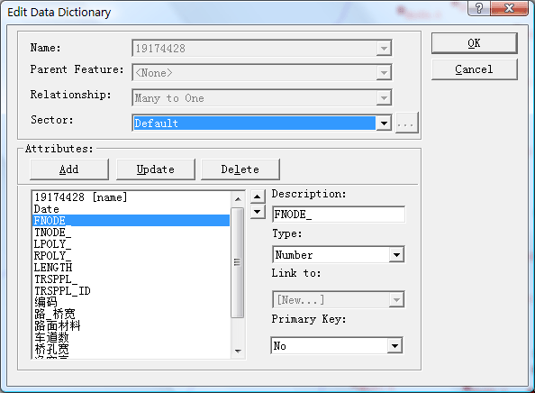
13, view and edit the data
dictionary:
Select
"Database | Edit
Attribute table structure ..."
submenu, you can open the following dialog box:
List box shows all the
attributes of the current database table, select the
database table you want to edit, then click the
"edit button" to open the structure of the database
table designer.
In this dialog, can be the
property of the structure of the design.
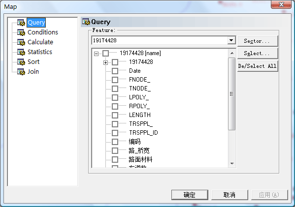
14 Spatial
Query
GISEDITOR
data structure to support both spatial data types,
such as polygon, line and point and non-spatial data
types, such as numbers and text.
Spatial query, which means you can
choose a standard-based data, such as which
functions overlap, cross, or at the specified
distance.
This
allows you to enable you to answer this
question, such as: What is the average residential
household income within the region in which?
To
check availability, select
"Query | SQL queries"
the following dialog box appears, through this
dialog box to complete the query:
15, Report Output:
1),
standard reports:
Operation is as follows:
Select the "Report
| Standard Reports
..." submenu, dialog
box pops up the following settings in this dialog
box, select your desired output of the contents of
the report:
Of course, you can click the button
below to check out the report via a query.
2), timing reports:
Select the "Report
| Timing Report
..." submenu, dialog
box pops up the following settings in this dialog
box, select your desired output of the contents of
the report.
Of course, you can click the button
below to check out the report via a query.
3) Summary Report:
Select the "Report
| District Report
..." submenu, dialog
box pops up the following settings in this dialog
box, select your desired output of the contents of
the report:
Of course, you can click the button
below to check out the report via a query.
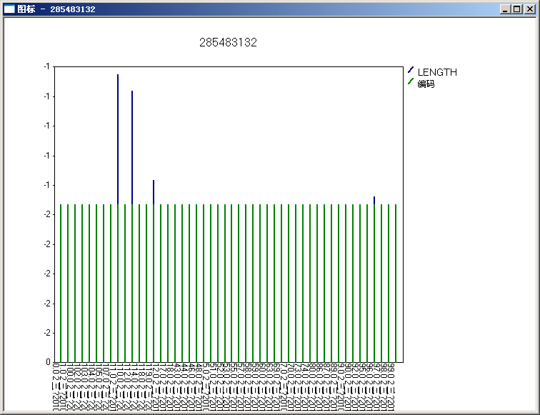
4),
column:
Select the "Report
| Histogram
..." sub-menu,
Settings dialog box pops up the following in this
dialog box, select your desired graphic output of
content
. Of course, you can click the button
below to query results output by a query graph.
5), the
timing diagram:
Select the "Report
| timing diagram
..." sub-menu,
Settings dialog box pops up the following in this
dialog box, select your desired graphic output of
content:
Of course, you can click the button
below to query results output by a query graph.
Below:
6), pie
chart:
Select the "Report
| Pie
..." sub-menu, Settings dialog box pops
up the following in this dialog box, select your
desired graphic output of content:
Of course, you can click the
button below to query results output by a query
graph.
Below:
12,
distance measurement
Select "Search |
Measuring distance" sub-menu to the canvas by
drawing a line to measure distance.
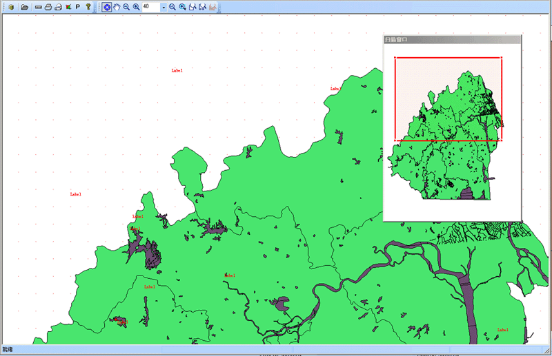
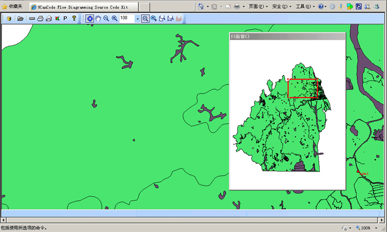
13, GisViewer program:
This program specifically designed
for the display and management GisEditor well
designed map files can browse, search, zoom, pan,
print reports, etc., as follows:
14, G is graphical
visualization OCX controls:
This procedure is based GisViewer the
OCX can perform the same function with the
GisViewer, but can be applied with the web and other
non-VC + + language development:
Summary:
Complete source code as a set of
VC + + / MFC library,
E-XD++ graphics
library visualization can you develop advanced
GIS application of any
savings of over 70% of
development time.
Gis your
application can be constructed on the basis of the
GisEditor.
GisEditor
all the source code can be customized according to
your needs.
Now in the National Bureau of
Statistics, Academy of Agricultural Sciences,
Forestry Research Institute, military, energy,
electricity, etc. a large number of units to be
widely used.
More
than 500 thousands lines "all
carefully designed and rigorously tested"
C/C++/.NET source codes, all complete source
codes is shipped without
any reservations!
Provide
more than 500 C + + extension class, more than 500 thousands lines of effective VC++ / MFC source code, more than 70
ready to use solution's source code, complete and
detailed online help system and user documentation,
supporting development tools designed!
Powerful,
flexible and easy to use graphical visualization of
source code libraries.
Powerful
and flexible components to create a variety of charts to meet
your needs.
Product
design specifications, it is easy to use, in just a
few days can be designed according to your needs
products.
We
provide complete support for products, download the
trial.
Feature-rich.
Ultra-versatile,
such as automatic layout, multi-level collapsible
subgraph, cell connection point, XML, DXF, SHP, SVG,
etc., can help you quickly create complex and
flexible chart.
Supports
a number of events: such as click, double click,
hover, select, rubber band select, copy, delete,
resize and move the support.
Support
the most complex operations: such as drag and drop,
unlimited undo / redo and clipboard operations and
so on.
Save
time and money to obtain reliability.
A
picture is worth a thousand words, E-XD++ offer more
than 500 thousands lines of well-designed and
well-tested C/C + +/.NET source code!
Development
takes years, thousands of customers worldwide
validation, can save you a lot of development time
and money!
Try
it now!
Do
not just listen to us say it a try!
Our
free trial includes all you need to prototype your
application.
Free
technical support.
 Products
 Download this solution

The official
version of the E-XD++component library visual
graphics solutions for enterprise version provides
all the source code, click the button below to
UCanCode
Order
:

Contact UCanCode Software
To buy the source code or learn more about with:
 GIS and SCADA,
SCADA Software With GIS, Real - Time Software with GIS, Source Code solution for C/C++, .NET GIS and SCADA,
SCADA Software With GIS, Real - Time Software with GIS, Source Code solution for C/C++, .NET
|